Geocoding Places
Navigation: RootsMagic 8 > Working With Places >
RootsMagic has the ability to "GeoCode" the places in your database. GeoCoding means to match the places in your database with a place in the 3.5 million name place database included with RootsMagic. When RootsMagic finds a match, it then adds the standardized place name as well as the latitude and longitude of the place to the place in the database so it can be plotted on a map.
GeoCoding Your Places
Open the Place page, select the 3 dot option menu and click GeoCode all places.
RootsMagic will go through your place list, looking for matches for each place. When RootsMagic finishes GeoCoding your database, there will most likely be some places that it was unable to find a match for.
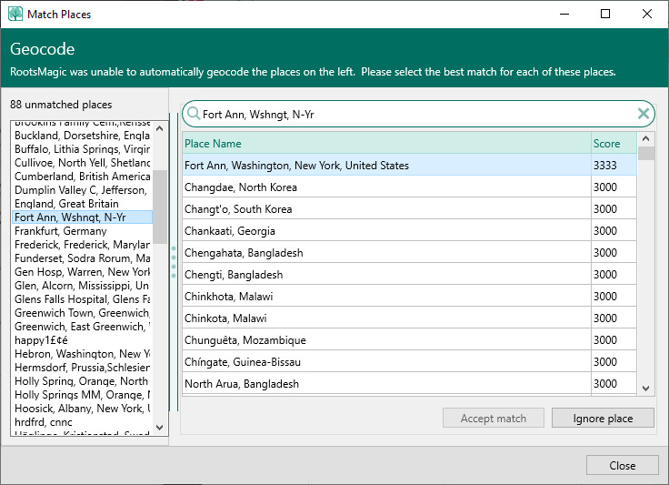
- RootsMagic will display a list of these places it was unable to match in the Match Places dialog.
- Highlight each place in turn, and the place name will appear in the "Search for" field.
- Search for – Click Search to have GeoCode search its database for close matches, which it will display in the "Matching Places" list, with a score indicating how how close the match appears to the program.
- Accept Match – If you find a suitable match, highlight the match and click Accept Match to tell RootsMagic to use the highlighted place as the location for the place in your database. The place name selected will be inserted into the standardized place name field, and the latitude and longitude will be updated with the coordinates. (Note: RootsMagic does not replace your place's original name, it simply updates the "standardized name" field as well as the latitude and longitude.)
- Ignore Place – Tells RootsMagic to ignore the place and move on to the next item in the list. This is useful when you encounter places in your data that aren't really places (like "in the army", etc.)
- After processing the last place in the list, the dialog will close. If you want to exit the dialog before you have had a chance to review all the items, click Close to return to the Place List.
Approximating Places Not Found
Be aware that the GeoCoding database may not work correctly for all countries, or all jurisdictions within a country. For instance, many provinces in Canada have four place levels, yet the Places Database only supports three place levels for Canada. As a result, place names, such as Peel Township, Wellington County, Ontario, Canada cannot be found and GeoCode suggests Peel [County], Ontario, Canada or Wellington [County], Ontario, Canada.
In these cases, try to find a nearby town, which will provide latitude and longitude values close to the desired place, along with a GeoCode "standardized" place name. Once you have the latitude and longitude values entered, you can change the standardized place name supplied to your own local version of what you need as a standardized place name. Since latitude and longitude values will be entered, GeoCode will not search for these places again.
Alternately, you can determine the exact latitude and longitude values, and enter the values and your own standardized place name, in which case GeoCode will ignore the place name thereafter.
